Not on air · 2 of 3 networks checked

Sparkgeo ads
- sparkgeo.com
- IT Services and IT Consulting
- CA
- 31 employees
Sparkgeo’s ads on LinkedIn, Meta and Google, recorded by adsrunning. Browse the latest here for free. Sign up free to see all 33. Watch Sparkgeo on any plan to get each new one in your feed.
Watchlist included in every plan
What Sparkgeo runs
- Single image · LinkedIn
- 2
- Video · LinkedIn
- 3
| Network | Status | Live ads | Nov 2025LinkedIn activity · 52 weeksNov 2026 | Checked | Next step |
|---|---|---|---|---|---|
| None recorded | 0 | Checked 7 Nov 2026 | See all 33 ads → | ||
| Meta | Not checked | — | |||
| None recorded | 0 | No ads found on the Google Ads Transparency Center | Checked 9 Nov 2026 | Collect them with the API → |
Sparkgeo has no live LinkedIn ads. We recorded no Google ads on 9 Nov 2026.
Latest ads
- LINKEDIN · VIDEOSince 8 Oct 2025
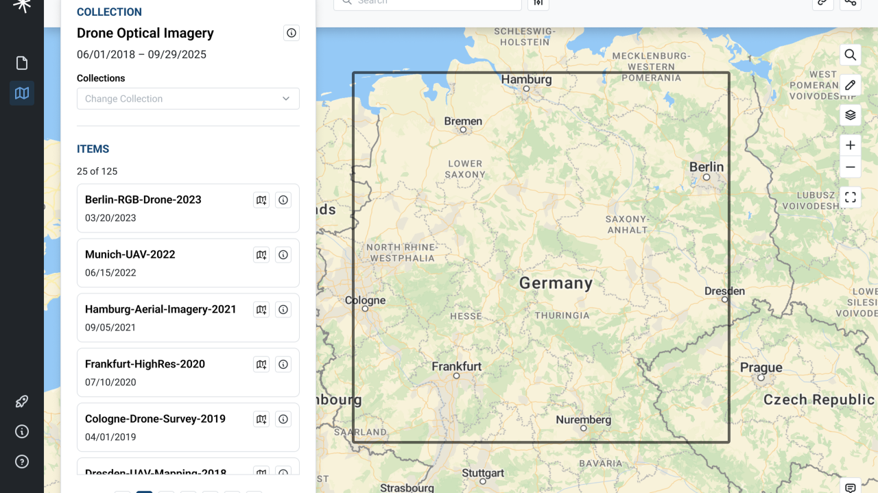
Hey airborne remote sensing companies - what if you had a tool that took your raw data, prepped it, and organized it? Prescient automates ingestion by supporting raw geospatial data and converting it into analysis-ready Cloud Optimized formats. This makes datasets faster to access, easier to visualize, and ready for your data managers and end users. Learn more about how when data is easy, geospatial will change everything here https://lnkd.in/g9cQUeTw #AirborneSupplyChain #Prescient #Data #CloudOptimized
- LINKEDIN · ARTICLERecorded 1 Oct 2026
The airborne remote sensing industry has always been about innovation, but the next innovation isn’t a new sensor or platform, it’s a better way of managing and delivering data. Prescient makes data explorable and cloud-based, so teams can easily search and access what they need, when they need it. #DataManagement #RemoteSensing #AerialAcquisition #Cloud
- LINKEDIN · IMAGERecorded 1 Oct 2026
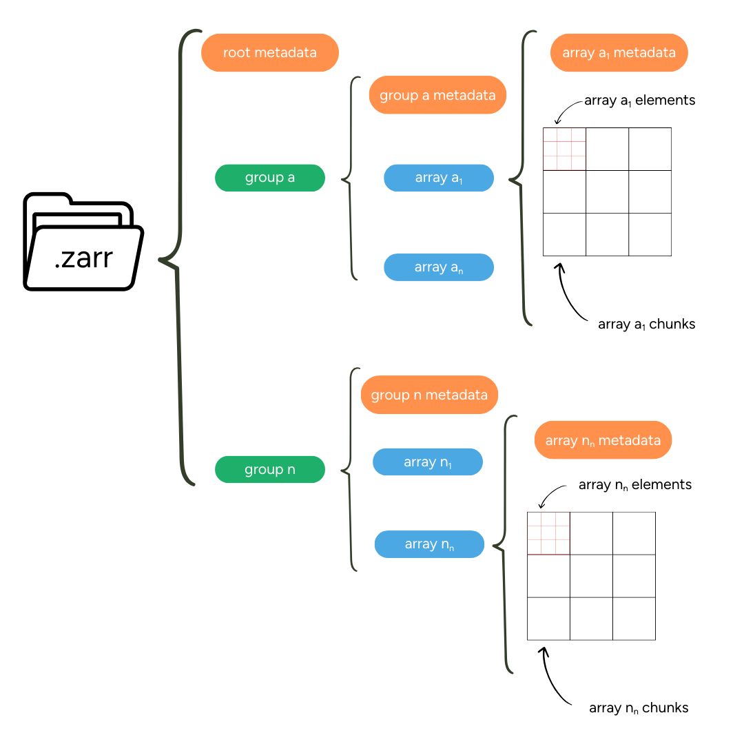
European Space Agency - ESA Sentinel missions are generating unprecedented volumes of Earth Observation data, but a lot of it remains in legacy formats. That is changing through the Earth Observation Processing Framework (EOPF) and the EOPF Toolkit, a community-driven project developed by thriveGEO, Development Seed, and Sparkgeo. The Toolkit helps new and experienced users adopt the cloud-native Zarr format for Copernicus Sentinel data, providing accessible, efficient tools for working in the cloud. At Sparkgeo, our role is to bridge the gap between these new cloud-native formats and the tools people already use, specifically QGIS. Learn more about the project, some useful workarounds until the next release of updates, and how you can get involved: https://lnkd.in/gXZSd7bh #EarthObservation #QGIS #CloudNative #Zarr #Geospatial #OpenSource #ESA #EOPF
- LINKEDIN · VIDEORecorded 1 Oct 2026
Geospatial intelligence is no longer just about maps; it’s about understanding complex systems, anticipating risks, and identifying opportunities through space and time. From securing borders to connecting remote communities, spatial technology is driving critical infrastructure and strategic insight. At Sparkgeo, we build practical, scalable tools that support real-time, location-based decision-making. Headquartered in Canada, our work is grounded in the values of a nation that is strong, free, and deeply committed to global security and resilience. Because when geospatial changes everything, it matters where it starts. Learn more at sparkgeo.com #GeospatialIsChangingEverything #CanadianTech #Geospatial #BuiltInCanada #StrongAndFree
- LINKEDIN · VIDEORecorded 1 Oct 2026
From the satellites guiding our operations to the data shaping tomorrow's decisions, geospatial technology is no longer peripheral. It's foundational. For Canada's defence and aerospace sector, it's everything. Geospatial and AI combined are how we protect Northern Sovereignty. How we optimize logistics. How we build smarter, more resilient systems. How we stay ahead. Because whether it's climate, defence, resources, or critical infrastructure - everything is somewhere. And understanding where we're going matters now more than ever. Geospatial is changing everything. Are you ready? #Geospatial #CanadianAerospace #Defence #NorthernSovereignty
- LINKEDIN · IMAGERecorded 1 Oct 2026
Will and Anthony are at the #CanadianAerospaceSummit in Ottawa this week, talking about how the future of Canada's aerospace and defence capabilities are being shaped, and a critical part of that is geospatial technology. Geospatial intelligence combined with AI isn't just transforming how we operate - it's redefining what's possible for Northern Sovereignty, resource management, and critical infrastructure protection. If you are here this week, let's talk about how geospatial is changing everything > https://lnkd.in/eyezuSmm Aerospace Industries Association of Canada (AIAC)\Association des industries aérospatiales du Canada | Evan Solomon | Bob Zimmer | Todd Doherty | Build Canada #GeospatialIsChangingEverything #CanadianAerospace #Defence
6 of 33 adsSign up to see every Sparkgeo ad, filter by format and date, and get alerts on new ones.
See all 33 adsQuestions about Sparkgeo’s ads
Is Sparkgeo running LinkedIn ads?
We recorded no live LinkedIn ads for Sparkgeo on 10 Nov 2026.
How many LinkedIn ads has Sparkgeo run?
LinkedIn’s ad library lists 32 ads for Sparkgeo. We recorded 33 LinkedIn ads for Sparkgeo, first recorded on 1 Oct 2026 and last recorded on 27 Oct 2026.
Does Sparkgeo run Google ads?
We recorded no Google ads for the domain sparkgeo.com on 9 Nov 2026.
Which ad formats does Sparkgeo use?
The 6 LinkedIn ads on this page include 2 image ads and 3 video ads.
Watch the companies you care about.
Filter every ad by industry, country, format and network, and get alerts when a company you watch starts running new ads.