1 new LinkedIn ad in 30 days · 2 of 3 networks checked

PhotoSat ads
- photosat.ca
- Technology, Information and Internet
- CA
- 32 employees
PhotoSat’s ads on LinkedIn, Meta and Google, recorded by adsrunning. Browse the latest here for free. Sign up free to browse our full recording. Watch PhotoSat on any plan to get each new one in your feed.
Watchlist included in every plan
What PhotoSat runs
- Single image · LinkedIn
- 2
- Video · LinkedIn
- 3
- Carousel · LinkedIn
- 1
| Network | Status | Last 30 days | Total ads found | Ad activity | Checked | Next step |
|---|---|---|---|---|---|---|
| Ads recorded | 1 | 38+ | 11/11/2026 | View ads → | ||
| Meta | Not checked | — | — | View ads → | ||
| None recorded | — | — | 11/06/2026 | View ads → |
PhotoSat has 1 new LinkedIn ad in the last 30 days. We recorded no Google ads on 6 Nov 2026.
Latest ads
- LINKEDIN · VIDEOSince 15 Oct 2026
While PhotoSat is best known for large-area topographic surveys, many operational decisions are made within relatively small areas of a mine site. Argus Surveys was developed specifically for those areas. PhotoSat's Argus Survey delivers satellite topographic surveys for operational areas under 10 km², providing a consistent elevation dataset that can be delivered in any file format and coordinate system. This helps make repeat surveys easier to compare and integrate with your existing survey data. It is designed to make frequent surveying more practical and cost-effective for smaller sites, where traditional surveys or drone access may be limited by cost or logistics. Argus provides: • 10–15 cm vertical accuracy (RMSE, with ground control) • Consistent coverage of dynamic operational areas • Up to biweekly revisits • Delivered within 3 days of data reception See how Argus fits alongside your current survey program 👉 https://bit.ly/4hJCxAc
- LINKEDIN · VIDEOSince 4 Aug 2026
Stockpiles, earthworks, tailings, waste dumps — they all change constantly. Knowing by how much, and when, drives real decisions. The challenge is capturing that change consistently, without a field crew on site for every measurement. This is where satellite surveying earns its place. At PhotoSat, every satellite-derived survey is reviewed and calibrated by our analysts against ground control, so results stay consistent across acquisition dates. With a vertical accuracy of better than 15 cm RMSE, that consistency is the key: because each survey lines up with the last, you can measure volumetric change between dates with confidence — comparing this month to last, or this year to the baseline — without sending a crew to site each time. For stockpile volumes, earthworks, and terrain movement, that means a consistent record of change over time, captured from space. Engineering-grade accuracy, when and where a field survey isn't practical. Want to know how much your site has changed since your last survey? Talk to our experts 👉 https://bit.ly/3RmTO9c #Mining #RemoteSensing #Satellite #Geospatial #MineSurveying
- LINKEDIN · CAROUSELSince 28 Jul 2026
See how PhotoSat helps you move faster, work safer, and cut costs at every phase of your project. Powered by proprietary deep learning and an in-house spectral library, our experts deliver end-to-end solutions for mining and exploration.
- LINKEDIN · IMAGESince 28 Jul 2026
Meet PhotoSat at Discoveries Mining Conference 2026! At Discoveries 2026 in Hermosillo, Mexico (August 4–6), discover how satellite alteration mineral mapping with proprietary deep-learning models trained on our in-house spectral library lets you see more and explore smarter. Stop by Booth #198 to see how expert-led satellite data analysis helps you: ▪️ Read each mineral's spectral fingerprint — every mineral absorbs and reflects light distinctively, and we use that to tell them apart ▪️ Identify alteration minerals with confidence — deep learning models trained on our in-house spectral library, not eyeballed spectral bands ▪️ Go further with next-gen hyperspectral — new models capable of detecting more minerals and distinguishing compositions and crystallinities from true hyperspectral data 🎤 Don't miss our featured talk, "Integrating Hyperspectral and Multispectral Satellite Datasets for Multi-Scale Alteration Mapping at the Champagne Project, Chile," August 4 at 3:15PM. 💡 Can't make it to Hermosillo? We've got you covered! Sign up to get conference highlights and the full presentation delivered straight to your inbox 👉 https://bit.ly/4yBFjPs
- LINKEDIN · VIDEOSince 8 Jul 2026
🛰️ Technical Tuesday | Episode 6 | Why Summer Is the Most Powerful Season for Satellite Geology Bare rock. Clear skies. No snow cover. It's peak Northern Hemisphere field season, and this is the most powerful window of the year for satellite alteration mapping in snow-affected terrain like BC's Golden Triangle. This week's episode walks through our alteration mapping work at the Red Mountain deposit in BC's Golden Triangle, using WorldView-3 (WV-3) satellite imagery and PhotoSat's proprietary deep-learning algorithms. Eight hydrothermal alteration minerals were identified across the property: Sericite, Calcite, Chlorite/Epidote, Montmorillonite, Jarosite, Goethite, Hematite, Iron oxide gossans. Each mineral is mapped on a possible-to-probable confidence scale and compiled into vector-format mineral maps, ready to layer with geophysics, geochemistry, or field geology data. Why WV-3? → At 3.7 m SWIR pixel size, WV-3 delivers property-scale detail. That resolution is what separates a regional overview from a drill-ready targeting tool. Why summer? → Snow cover absorbs and scatters SWIR wavelengths, masking the very absorption features that identify alteration minerals. Remove the snow and the geology speaks clearly. That is exactly where we are right now. Archive imagery is available for some project areas. New tasking can be ordered now. Read the full report 👉 https://bit.ly/4vkv7YK Questions about the methodology? Drop them in the comments. #AlterationMapping #GoldenTriangle #WorldView3 #MineralExploration #RemoteSensing #Geoscience #PhotoSat #SatelliteImagery #Exploration
- LINKEDIN · IMAGESince 22 Jun 2026
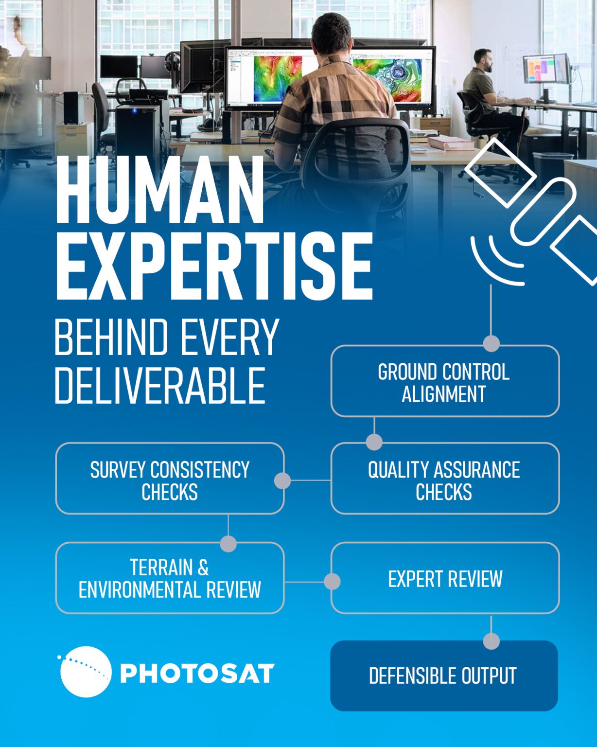
Most people see the final map, model, or monitoring result. What they don’t see is everything that happens in between. At PhotoSat, satellite data isn’t simply downloaded and delivered through an automated pipeline. Every project moves through a production workflow guided by PhotoSat's human expertise, supported by deep learning processing, to ensure the outputs are actionable and defensible. That includes: ▪️ Ground control alignment ▪️ Quality assurance checks ▪️ Survey consistency validation ▪️ Terrain and environmental review ▪️ Expert review from geospatial specialists and subject matter experts Because in mining and infrastructure projects, decisions are only as good as the confidence behind the data. Technology helps us move faster. Expertise ensures we deliver accuracy teams can rely on. That balance is what makes PhotoSat different. Learn more about us: 👉 https://bit.ly/4qFhJfu


6 of 38+ adsSign up to see every PhotoSat ad, filter by format and date, and get alerts on new ones.
See all 38+ adsQuestions about PhotoSat’s ads
Does PhotoSat have new LinkedIn ads?
Yes. We found 1 new LinkedIn ad for PhotoSat in the 30 days to 12 Nov 2026.
How many LinkedIn ads has PhotoSat run?
LinkedIn’s ad library lists 38 ads for PhotoSat. We recorded 38 LinkedIn ads for PhotoSat, first recorded on 28 Sept 2026 and last recorded on 17 Oct 2026.
Does PhotoSat run Google ads?
We recorded no Google ads for the domain photosat.ca on 6 Nov 2026.
Which ad formats does PhotoSat use?
The 6 LinkedIn ads on this page include 2 image ads, 3 video ads and 1 carousel ad.
Watch the companies you care about.
Filter every ad by industry, country, format and network, and get alerts when a company you watch starts running new ads.